
Vintage Route: Guanay & Tipuani
A Glimpse into the 2006 Gold Rush
Take a trip back to 2006 with me to the mining regions of Guanay and Tipuani, Bolivia. This was a family expedition involving cable carts, river boats, and the incredible landscapes of the Yungas. These photos capture the entrance of the underground mine just months before it was closed due to a major landslide.
Full Photo Album: https://www.flickr.com/photos/f-jauregui/sets/72157594360668289"
A Travel photography is often about capturing a moment in time, but every so often, those moments become historical records. Looking back at my archives from 2006, I found a series of photos that feel like they belong to a different era of the Andes. This was a time before paved highways reached deep into the Amazon basin, before GPS was in every pocket, and when the gold mining towns of Guanay and Tipuani felt like the true "Wild West" of Bolivia.
This wasn't just a scouting mission for my blog; it was a weekend shared with good friends and family. I was joined by Thomas and his children, along with my son Michael. We set out from my home at the time—the Hotel Esmeralda in Coroico—and descended into the humid, high-stakes world of the gold rush.
The Descent into Guanay
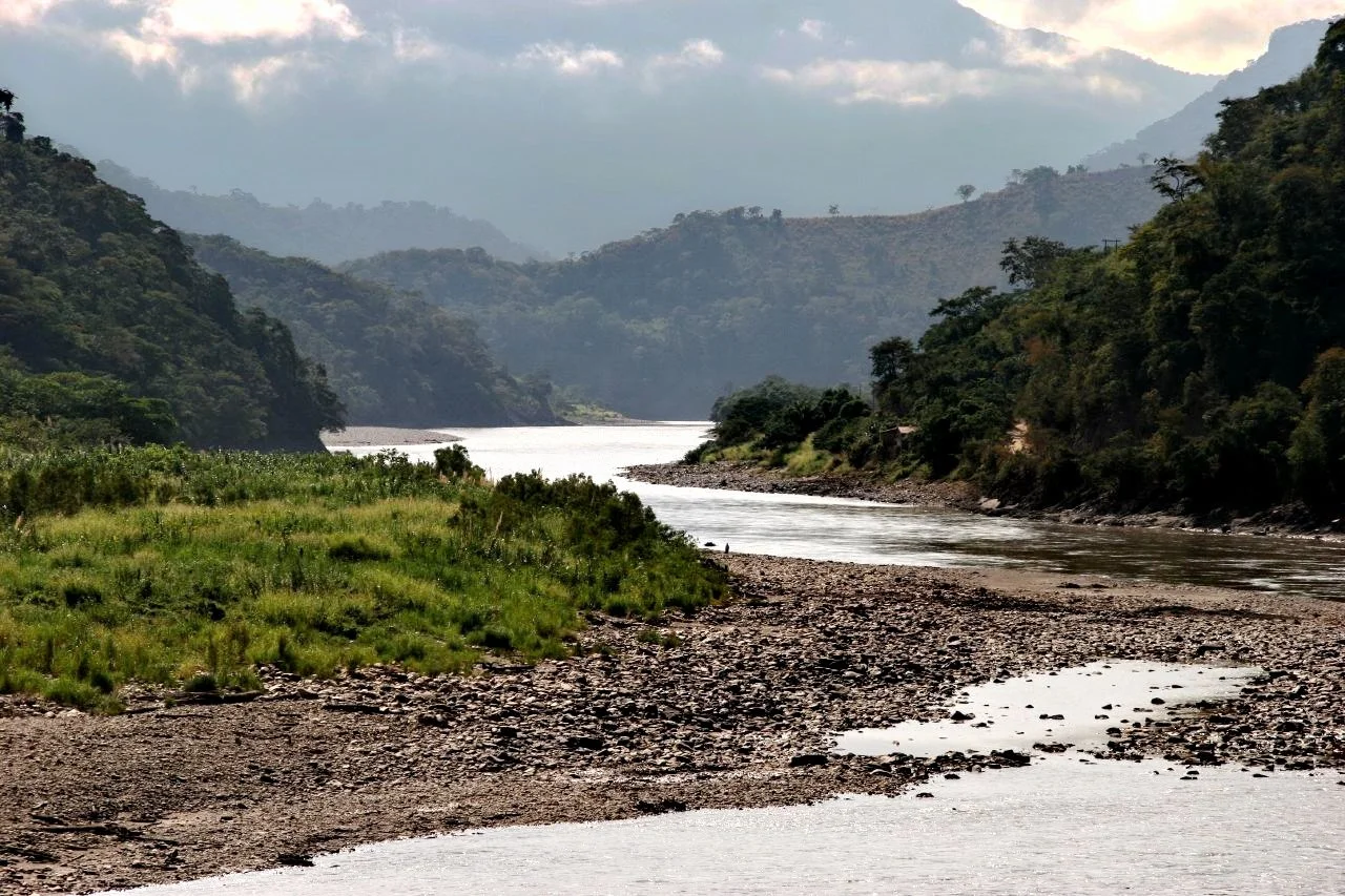
The journey from the cool, cloud-forested heights of Coroico down to Guanay is a transition of both climate and culture. As you drop in altitude, the air thickens, the vegetation turns a deeper shade of emerald, and the quiet mountain life gives way to the frantic energy of the mining districts.
Our base for the first day was the home of Edgar Kann in Guanay. Edgar was a fixture in the local mining scene, and his hospitality provided us with a front-row seat to the industry that fuels this entire region. Guanay sits at the confluence of the Mapiri and Tipuani rivers, a strategic point where the wealth of the mountains is washed down in the form of gold dust and nuggets.

Crossing the Divide: The Canastilla
One of the most visceral memories of that first day—and a highlight for the kids—was our visit to the mining company’s site. In the Yungas, infrastructure is often a matter of necessity over elegance. To reach the site, we had to cross the river using a cable cart, or canastilla.
There is a specific kind of thrill that comes from hanging in a metal cage suspended by a steel cable, with the brownish, churning waters of the Rio Mapiri rushing beneath you. It’s a moment where you realize how much the people here rely on their own ingenuity to conquer the geography. As a photographer, the perspective from the middle of the river, suspended in mid-air, offered a unique angle of the valley that no bridge could ever provide.
After the adrenaline of the crossing, we settled in for a "hardy lunch" at a riverside patio. The architecture of the region is functional: wooden supports and metal shingle roofs. I can still remember the sound of that afternoon—the distant roar of the river and the occasional "ping" of the metal roof expanding under the relentless tropical sun. It was the perfect moment of stillness in a region that is usually defined by movement and labor.
The Ghost of the Underground Mine
Later that afternoon, we visited the entrance of a massive underground mine. At the time, it was an impressive feat of engineering, a dark maw in the side of the mountain where men sought their fortunes deep within the rock.
We didn't know it then, but we were standing at the entrance of a site that was about to be reclaimed by nature. Later that same year, a massive landslide occurred a few miles upstream. The mountain literally moved, altering the course of the landscape and forcing the permanent closure of the mine. Looking at the photos in my Flickr album, you can see the entrance as it was—a gateway to the earth that no longer exists. It serves as a somber reminder of how fragile human enterprise is in the face of the Andes' geological power.
Up the Rio Tipuani: The Spalt and the Rapids
The second day of our trip took us even deeper into the wilderness. We traded our land vehicles for a small, canoe-sized boat to navigate the Rio Tipuani. This river is legendary in Bolivia; for centuries, it has been synonymous with gold.
Navigating a small boat up-river against the current is an art form. The boatmen know every eddy and every hidden rock. We were heading toward a specific geological feature—a "spalt" or a narrow split in the mountain where the river is squeezed between towering walls of stone.
For a photographer, this was the "Holy Grail" of the trip. The rapids surged through the narrow gap, creating a white-water chaos that contrasted beautifully with the rock. But the most striking detail was the vegetation. Huge ferns overhung the rapids, clinging to the vertical rock faces and dripping with the spray from the river. The light filtered down through the canopy, creating a prehistoric, "Lost World" atmosphere. It was a place of intense natural beauty, tucked away in a corner of the world that few travelers ever get to see.
Reflections on a Changing Landscape
The trip concluded with the long climb back up the mountainside to Coroico. Arriving back at the Hotel Esmeralda, looking out over the velvet-green ridges of the Yungas, the contrast was sharp. We had spent 48 hours in the grit, mud, and raw power of the mining camps, and returning to the "City of Eternal Spring" felt like returning from a different century.
Looking at these photos today, I am struck by how much has changed. My son Michael and Thomas’s kids have grown up; the mine we visited is buried under tons of earth; and the roads to Guanay are better than they used to be. Yet, the spirit of the region remains. The gold is still there, the rivers still roar, and the ferns still hang over the Tipuani rapids.
This 2006 expedition was more than just a weekend getaway. It was part of the foundation of what RutasFotosInfo is today: a quest to document the routes, the people, and the fleeting moments of beauty in the high Andes and the deep valleys.

To ensure you have coverage throughout South America, we suggest using Global66 cards and accounts. These are widely accepted in the region. Global66 is a financial platform based in Chile that has teamed up with FC Bayern Munich to provide benefits for Latin Americans.
Try Global66 and order your card today. Sign up and get $10 off your first transaction. -click here -
Technical Note for Photographers
The 2006 gallery was shot during a transition period in photography. The textures of the mining sites—the rusted machinery, the muddy river water, and the dark interiors of the mine—required careful exposure to maintain detail in both the shadows and the bright tropical highlights. You can see the full collection, including the shots of the cable cart and the Tipuani "spalt," in high resolution on my Flickr page.


La Ruta Vintage
Guanay y Tipuani: Un Vistazo a la Fiebre del Oro de 2006
La fotografía de viajes es, en esencia, capturar un instante, pero a veces esos instantes se convierten en documentos históricos. Revisando mis archivos de 2006, encontré una serie de fotos que parecen pertenecer a otra era de los Andes. Era una época antes de que las carreteras pavimentadas llegaran a lo profundo de la cuenca amazónica y antes de que el GPS estuviera en cada bolsillo. En ese entonces, los pueblos mineros de Guanay y Tipuani se sentían como el verdadero "Lejano Oeste" de Bolivia.
Esta no fue solo una misión de exploración para mi blog; fue un fin de semana compartido con grandes amigos y familia. Me acompañaron Thomas y sus hijos, junto con mi hijo Michael. Salimos desde lo que era mi hogar en ese momento, el Hotel Esmeralda en Coroico, y descendimos hacia el mundo húmedo y de alto riesgo de la minería aurífera.
El Descenso a Guanay
El viaje desde las alturas frescas de Coroico hasta Guanay es una transición de clima y cultura. A medida que pierdes altitud, el aire se vuelve denso, la vegetación adquiere un verde esmeralda más profundo y la vida tranquila de la montaña da paso a la energía frenética de los distritos mineros.
Nuestra base el primer día fue la casa de Edgar Kann en Guanay. Edgar era una figura clave en la escena minera local y su hospitalidad nos brindó un asiento en primera fila para observar la industria que mueve a toda esta región.
Cruzando el Abismo: La Canastilla
Uno de los recuerdos más vivos de ese primer día fue nuestra visita al sitio de la compañía minera. En los Yungas, la infraestructura es a menudo una cuestión de necesidad. Para llegar al sitio, tuvimos que cruzar el río utilizando una canastilla (un carrito de cable).
Hay una adrenalina especial al colgar de una jaula de metal suspendida por un cable de acero, con las aguas marrones y turbulentas del Río Mapiri corriendo debajo de ti. Después del cruce, disfrutamos de un almuerzo contundente en un patio junto al río. Todavía puedo recordar el sonido de esa tarde: el rugido distante del agua y el "ping" ocasional del techo de tejas metálicas expandiéndose bajo el implacable sol tropical.
El Fantasma de la Mina Subterránea
Esa tarde visitamos la entrada de una enorme mina subterránea. No lo sabíamos entonces, pero estábamos viendo un sitio que estaba a punto de desaparecer. Ese mismo año, un derrumbe masivo un par de millas río arriba cambió el curso del paisaje y obligó al cierre permanente de la mina. Ver las fotos hoy en mi álbum de Flickr se siente como observar un mundo perdido.
Hacia el Río Tipuani: El "Spalt" y los Rápidos
El segundo día nos adentramos aún más en la selva. Cambiamos nuestros vehículos por un pequeño bote, del tamaño de una canoa, para navegar el Río Tipuani.
Para un fotógrafo, este fue el punto máximo del viaje. El río se estrechaba en un "spalt" (una grieta) en la montaña, donde los rápidos rugían entre paredes de roca. Lo más impactante eran los helechos gigantes que colgaban sobre el agua blanca, creando una atmósfera de "Mundo Perdido".
Regresamos a Coroico con el polvo de las minas en la ropa, sabiendo que habíamos presenciado algo especial. Esta expedición de 2006 es parte de la base de lo que hoy es RutasFotosInfo.
Guanay & Tipuani: Ein Einblick in den Goldrausch von 2006
Reisefotografie bedeutet oft, einen Moment festzuhalten, aber manchmal werden diese Momente zu historischen Dokumenten. Beim Durchsehen meiner Archive aus dem Jahr 2006 fand ich eine Serie von Fotos, die sich wie aus einer anderen Ära der Anden anfühlen. Es war eine Zeit, bevor asphaltierte Straßen die Tiefen des Amazonasbeckens erreichten und bevor GPS in jeder Tasche steckte. Damals fühlten sich die Minenstädte Guanay und Tipuani wie der wahre „Wilde Westen“ Boliviens an.
Dies war nicht nur eine Scouting-Tour für meinen Blog; es war ein Wochenende mit guten Freunden und der Familie. Thomas und seine Kinder sowie mein Sohn Michael begleiteten mich. Wir starteten von meinem damaligen Zuhause – dem Hotel Esmeralda in Coroico – und stiegen hinab in die feuchte, riskante Welt des Goldrausches.
Der Abstieg nach Guanay
Die Reise von den kühlen, nebelverhangenen Höhen Coroicos hinunter nach Guanay ist ein Übergang von Klima und Kultur. Je tiefer man kommt, desto dicker wird die Luft, die Vegetation nimmt ein tieferes Smaragdgrün an, und das ruhige Bergleben weicht der hektischen Energie der Minendistrikte.
Unsere Basis am ersten Tag war das Haus von Edgar Kann in Guanay. Edgar war eine feste Größe in der lokalen Minenszene, und seine Gastfreundschaft ermöglichte uns einen direkten Einblick in die Industrie, die diese gesamte Region antreibt.
Über den Abgrund: Die Canastilla
Eine der lebhaftesten Erinnerungen an diesen ersten Tag war unser Besuch auf dem Gelände der Minengesellschaft. In den Yungas ist Infrastruktur oft eine Frage der Notwendigkeit. Um das Gelände zu erreichen, mussten wir den Fluss mit einer Canastilla (einer Seilbahn-Gondel) überqueren.
Es ist ein ganz besonderer Nervenkitzel, in einem Metallkäfig an einem Stahlseil zu hängen, während unter einem die bräunlichen, aufgewühlten Wassermassen des Rio Mapiri vorbeirauschen. Nach der Überquerung gönnten wir uns ein herzhaftes Mittagessen auf einer Terrasse am Flussufer. Ich kann mich noch genau an den Klang dieses Nachmittags erinnern: das ferne Rauschen des Flusses und das gelegentliche „Pingen“ des Metallschindeldachs, das sich unter der unerbittlichen Tropensonne ausdehnte.
Der Geist der Untertagemine
Später am Nachmittag besuchten wir den Eingang einer gewaltigen Untertagemine. Wir wussten es damals noch nicht, aber wir standen am Eingang eines Ortes, der kurz davor war, von der Natur zurückerobert zu werden. Noch im selben Jahr ereignete sich einige Meilen flussaufwärts ein gewaltiger Erdrutsch, der die Landschaft veränderte und die dauerhafte Schließung der Mine erzwang. Wenn ich mir die Fotos heute in meinem Flickr-Album ansehe, fühlt es sich an wie der Blick in eine untergegangene Welt.
Auf dem Rio Tipuani: Der „Spalt“ und die Stromschnellen
Am zweiten Tag drangen wir noch tiefer in die Wildnis vor. Wir tauschten unsere Fahrzeuge gegen ein schmales Boot in Kanugröße, um den Rio Tipuani flussaufwärts zu befahren.
Für einen Fotografen war dies der Höhepunkt der Reise. Der Fluss drängte sich durch einen „Spalt“ im Berg, wo die Stromschnellen zwischen hohen Felswänden tosten. Das beeindruckendste Detail war die Vegetation: Riesige Farne hingen über den Stromschnellen und klammerten sich an die vertikalen Felswände. Es herrschte eine prähistorische „Lost World“-Atmosphäre.
Wir kehrten nach Coroico zurück, den Staub der Minen noch auf der Kleidung, in dem Wissen, etwas Einzigartiges erlebt zu haben. Diese Expedition von 2006 ist ein Teil des Fundaments dessen, was RutasFotosInfo heute ausmacht.